SUMMARY: 5.7k feet, 0.25 miles
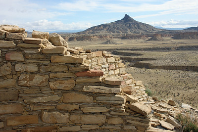
DESCRIPTION: Guadalupe Ruin is a masonry pueblo ruin, the easternmost Chacoan outlier, on top of an isolated 200 foot mesa.
This site is about 7.5 miles away from a remote stretch of the CDT.
Correct map coming someday!
GETTING THERE: From the BLM website: Guadalupe Ruin is approximately two hours from Albuquerque. From I-25, take exit 242 to US 550. 41.6 miles towards Cuba, take a left at the San Luis-Cabezon turnoff (between mileposts 41 and 42) on CR 279. At 8.5 miles, the road turns to dirt. At 12.3 miles stay right. At 13.8 miles, continue straight. At 17.2 miles, there is a left turn that tops out on a rise; stay to the left on the main road. At 21.5 miles, stay left (although it looks like the main road is to the right, it is not. However, if you wish to camp, this is the road to take to the top of Mesa Chivato). At about 29 miles, there is a deep low water crossing that may become impassible during and after rainstorms. At 29.5 miles, the parking lot and access trail to the Ruin is on the left. The parking area is best entered from the second entrance.-Guadalupe Ruin is accessed by a steep, unimproved recently-improved footpath.
CONDITIONS: Steep climb, but the view of Cabezon at the top is worth it.
NMVFO has done work on this trail:
